Think Rubber Chicken's theory about the storm drain now being defunct is very logical. When I saw it this year, it just looks so very old and something that has been left there.
We go again next February and will have the time to ask around. If the general concensus is that it is, or was a storm drain, then I guess that is what we have to live with.
The "square slab" in the tidal pool
Moderator: Styles Bitchley
-
rubber chicken

- Master Location Sleuth
- Posts: 691
- Joined: Mon Apr 30, 2007 4:53 am
- Location: Great Lakes region
I'm still having trouble with the concept of needing a storm drain there. Storm drains are typically used in urban areas that have been paved over and built up, or in areas where the natural topography has been disturbed. It doesn't seem as if these conditions apply to the area near the Anderson Estate. The estate grounds appear to have been graded, but the land still slopes toward the ocean.
I'm sure most everyone on the forum is more familiar with the history of the area than I am, however. Guess it's time to look up the history of the development of that side of the island.
I'm sure most everyone on the forum is more familiar with the history of the area than I am, however. Guess it's time to look up the history of the development of that side of the island.
Higgins: You've washed the car?! How extraordinary. Why would you do such a thing?

-
golfmobile

- Chopper Pilot Wannabe
- Posts: 1203
- Joined: Fri Apr 06, 2007 8:47 pm
- Location: Atlanta area
- Contact:
I didn't find the structure to be unslightly, but then I'm somewhat prejudiced to find it appealing due to the MPI connection.
Considering that fact that I was appalled that the estate basically has no beach any longer (i.e., the water is all the way up to the retaining wall at high tide, and even at low tide, the water line is about only 10 feet from the wall, and the sand of this beach never has time to dry out, even up by the gate! -- it looks NOTHING like the beach we always see TM and JQH walking or jogging along), I think it may have been constructed when the water line was MUCH farther out from the beach. Perhaps it was right AT the water line when first built. This would make a lot more sense -- allow the water to run off from the yards of the houses along this stretch of the road instead of gutters. Over the years, as the sand washed in and stayed, the hole and its usage for run-off has been eliminated (though it was open enough to cause debris to be in the tidal pool 20 years ago during the filiming of MPI, as told to us by "CM Michael"). In addition, some other sort of drainage may have been installed in the intervening years as the area became more populated with more need for water lines, sewage, etc.
Therefore, maybe it shouldn't be the "poop stoop" as water run-off in Hawaii hopefully doesn't have much poop (it's not Mexico!) -- maybe it's more like the "gutter shutter."
golf
P.S. This shows the gate and how it is wet sand up to this gate (and both of these were taken at low tide):

This shows how little beach there really is and the sand is wet all the way up to the retaining wall:

Considering that fact that I was appalled that the estate basically has no beach any longer (i.e., the water is all the way up to the retaining wall at high tide, and even at low tide, the water line is about only 10 feet from the wall, and the sand of this beach never has time to dry out, even up by the gate! -- it looks NOTHING like the beach we always see TM and JQH walking or jogging along), I think it may have been constructed when the water line was MUCH farther out from the beach. Perhaps it was right AT the water line when first built. This would make a lot more sense -- allow the water to run off from the yards of the houses along this stretch of the road instead of gutters. Over the years, as the sand washed in and stayed, the hole and its usage for run-off has been eliminated (though it was open enough to cause debris to be in the tidal pool 20 years ago during the filiming of MPI, as told to us by "CM Michael"). In addition, some other sort of drainage may have been installed in the intervening years as the area became more populated with more need for water lines, sewage, etc.
Therefore, maybe it shouldn't be the "poop stoop" as water run-off in Hawaii hopefully doesn't have much poop (it's not Mexico!) -- maybe it's more like the "gutter shutter."
golf
P.S. This shows the gate and how it is wet sand up to this gate (and both of these were taken at low tide):
This shows how little beach there really is and the sand is wet all the way up to the retaining wall:
"Portside, buddy."
-
rubber chicken
- Master Location Sleuth
- Posts: 691
- Joined: Mon Apr 30, 2007 4:53 am
- Location: Great Lakes region
I'm thinking that what is (or was?) being drained is coming from across the road from the estate.
From what we've seen in the show it seems like the road slightly gains in elevation in both directions going away from the estate. So the area across the road from the estate driveway entrance could be the low spot where water is collected after coming off the cliffs near the estate, and also that which drains to the side of the road away from the ocean.
And about the beach - according to the first graph on wikipedia's sea level rise page, sea level has risen about six or seven centimeters since 1980 (my eyeball estimation). That might explain why the beach has changed, but it's just an uneducated guess. And beaches do tend to change slightly over time anyway. Whatever the reason it's too bad.
I think I've mentioned here before about a beach on Lake Superior where I used to go backpacking. When I first was at the beach it was perfectly graded down to the water and was about 30 or so feet wide. When I went back maybe four years later the beach was only about 5 to 10 feet wide and at the edge it fell almost vertically into the water 5 feet below. The rest of the sand was presumably off shore waiting to be washed back up into a beach again. I was really bummed out after backpacking a few days to get there. I later found out that Lake Superior's water level can change by a foot in a year, and even 6 inches in a month.
From what we've seen in the show it seems like the road slightly gains in elevation in both directions going away from the estate. So the area across the road from the estate driveway entrance could be the low spot where water is collected after coming off the cliffs near the estate, and also that which drains to the side of the road away from the ocean.
And about the beach - according to the first graph on wikipedia's sea level rise page, sea level has risen about six or seven centimeters since 1980 (my eyeball estimation). That might explain why the beach has changed, but it's just an uneducated guess. And beaches do tend to change slightly over time anyway. Whatever the reason it's too bad.
I think I've mentioned here before about a beach on Lake Superior where I used to go backpacking. When I first was at the beach it was perfectly graded down to the water and was about 30 or so feet wide. When I went back maybe four years later the beach was only about 5 to 10 feet wide and at the edge it fell almost vertically into the water 5 feet below. The rest of the sand was presumably off shore waiting to be washed back up into a beach again. I was really bummed out after backpacking a few days to get there.
-
J.J. Walters

- Founding Father
- Posts: 4196
- Joined: Tue Jan 02, 2007 10:54 pm
- Location: Suburbia, USA
- Contact:

-
golfmobile
- Chopper Pilot Wannabe
- Posts: 1203
- Joined: Fri Apr 06, 2007 8:47 pm
- Location: Atlanta area
- Contact:
James,James J. Walters wrote:Check out this shot from "Little Girl Who"...
Look how close the "slab" is to the beach. And look how much bigger the beach was then, compared to today!
Not sure how good of a frame of reference this is, but check out the scene in "No Need To Know" when the guy on the sailboat scuba dives in to plant the bomb.
If you see the scene with Magnum and Mandy, there appears to be a good deal of water between the beach and the stone slab. 6 years later, sand has accumulated UP to the stone slab.
So this tells me a few things.
Either
A) They have SUPER high and low tides
B) The erosion and accumulation of the beach is cyclical
or
C) Magnum used some wicked Camera angles at certain tide times.
Although I'm probably wrong!
Golf's photo takes in part of the Estate's retaining wall so you dont see all the beach, whereas in one of Steve's photo posted earlier this month, you can see more beach. However nothing like in the days of Magnum. If you look at that picture James posted, it looks as though the lower part of the sand on the beach is wet, but top part isnt. Perhaps an indication that in those days, the tide didnt even come up to where it does today?
When I was there this year, there wasnt much water between the beach and the concrete slab, so must have hit it just right, tide wise.
Who is going there next? Think Icepick was, but he hasnt been around recently. Anyone heard from him?
When I was there this year, there wasnt much water between the beach and the concrete slab, so must have hit it just right, tide wise.
Who is going there next? Think Icepick was, but he hasnt been around recently. Anyone heard from him?
-
rubber chicken
- Master Location Sleuth
- Posts: 691
- Joined: Mon Apr 30, 2007 4:53 am
- Location: Great Lakes region
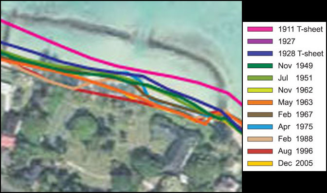
In this large .jpg from the University of Hawaii School of Ocean & Earth Science & Technology website, the rate of beach erosion in the Waimanalo area can be seen.
It's a bit hard to make out in the small area around the estate, but the picture shows that the estate area has been eroding pretty steadily since measurements were first taken in 1911. Even greater beach erosion has occurred just northwest of the estate, but the rest of Waimanalo beaches have actually been added to.
However, according to these lines the area nearest the the concrete box was most eroded in 1988, near the end of Magnum P.I. filming. (And largely the same in 1996). On the picture this is where the brown line (1988) dips into the red (1996) north of the estate tennis court.
I can only see the 1975 line (light blue) near where the main entrance from the estate to the beach is. But near the slab it must be under the biggest mass of lines (which include dark and light green).
I think I see the 2005 line (a sickly yellow color) peeking out from underneath the orange line near the main beach entrance, but it's hard to be certain. If that's correct then it looks like it follows the orange 1963 line past the slab, which would mean there is more beach there now than in 1988 (and 1996).
I made this close-up image including the color code to see all this easier. Picture is 300% normal size.
Last edited by rubber chicken on Sun Sep 06, 2009 5:40 pm, edited 1 time in total.
-
golfmobile
- Chopper Pilot Wannabe
- Posts: 1203
- Joined: Fri Apr 06, 2007 8:47 pm
- Location: Atlanta area
- Contact:
-
J.J. Walters
- Founding Father
- Posts: 4196
- Joined: Tue Jan 02, 2007 10:54 pm
- Location: Suburbia, USA
- Contact:


-
golfmobile
- Chopper Pilot Wannabe
- Posts: 1203
- Joined: Fri Apr 06, 2007 8:47 pm
- Location: Atlanta area
- Contact: