oops, did I write that loud?
From Moscow to Maui (2.4)
Moderator: Styles Bitchley
-
Pahonu

- Robin's Nest Expert Extraordinaire
- Posts: 2651
- Joined: Mon Aug 31, 2009 2:19 am
- Location: Long Beach CA
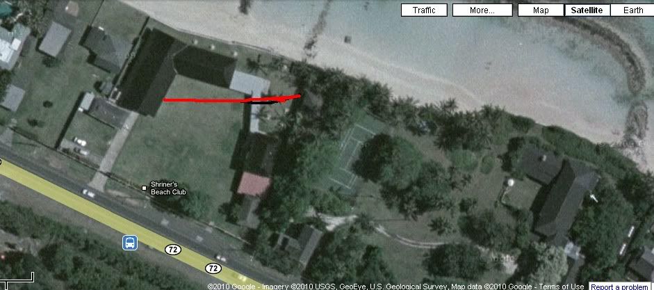
Did anyone notice at the 8:30 mark you can see the neighboring property from the guest house lanai. This was almost always hidden in other episodes by hanging blinds, but there seems to be a structure far in the distance. I was a little confused by this because in the very next season's Foiled Again the guest house was seen from a building very close to the property line wall. It seems the building near the guest house has vanished, and a distant building is visible! I know this had been discussed in other forum threads, but is anything known for certain?

Pahonu wrote:Did anyone notice at the 8:30 mark you can see the neighboring property from the guest house lanai. This was almost always hidden in other episodes by hanging blinds, but there seems to be a structure far in the distance.

In "Foiled again" I don't think the building was so close to the property line wall :I was a little confused by this because in the very next season's Foiled Again the guest house was seen from a building very close to the property line wall. It seems the building near the guest house has vanished, and a distant building is visible! I know this had been discussed in other forum threads, but is anything known for certain?


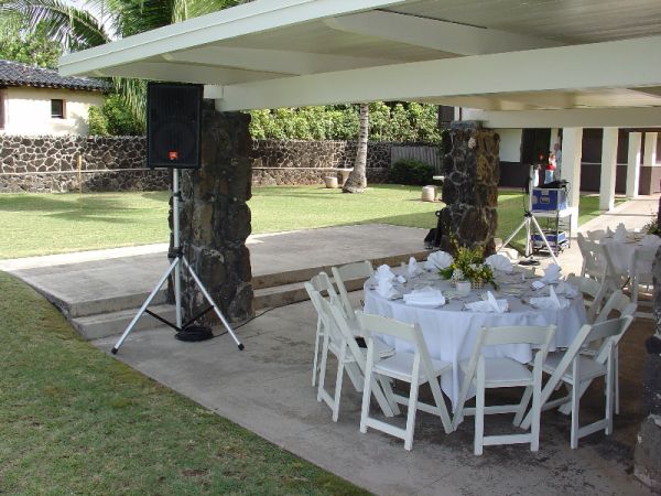
(Picture from http://magnum-mania.com/images/shriners ... b_full.jpg)

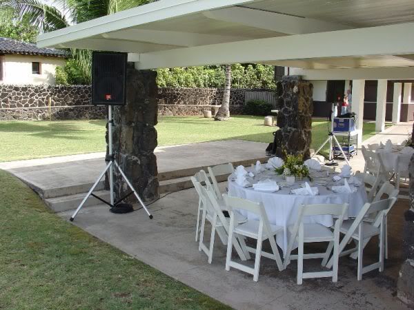
The Shriners Beach Club is used for events like weddings, birthday parties and other gatherings.
The next MPI fans meeting will be there
-
Pahonu
- Robin's Nest Expert Extraordinaire
- Posts: 2651
- Joined: Mon Aug 31, 2009 2:19 am
- Location: Long Beach CA
Thanks for the pictures Olivier!
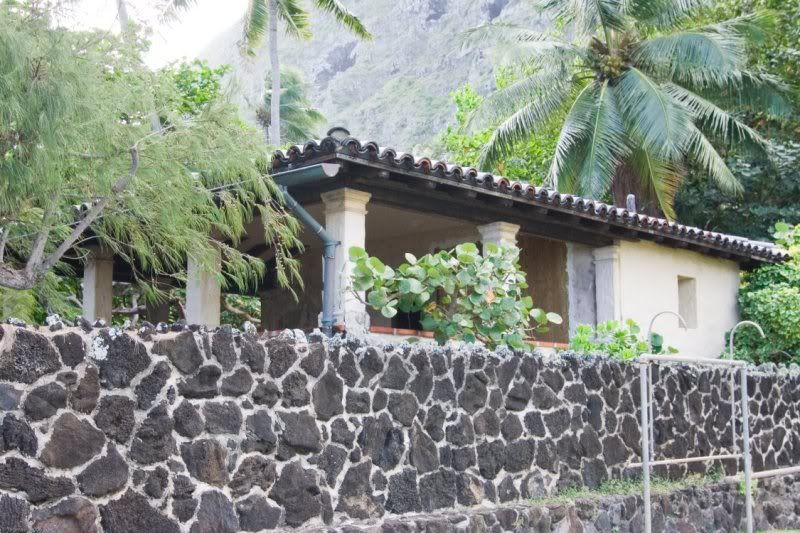
Your right, the structure in Foiled Again appears closer to the estate wall than it really is. It also appears to have glass windows and doors enclosing it which aren't in the fourth picture. Maybe they're removable for inclement weather? This threw me off, as I pictured it as an actual building rather than an enclosed porch of sorts.
What's really interesting to me in the fourth picture is the distinct mortar line about a third of the way up the wall. This indicates the wall was originally much lower and added on to later. Why would a perimeter wall be built so low unless it wasn't the property line? This might be a clue that the neighboring Shriner's property was once part of the estate.
What do we know about the age of the buildings on the Shriner's property? Older pictures from Hawaii Five-0 showed a two-story building behind the boathouse and a dock. I seem to recall others have speculated the property was once originally part of the estate back in the 30's because the tide pool walls extend across the beach of both properties. Anyone have any thoughts?
That building was built prior to the start of MPI.
In the first picture.the structure you see is from this angle.
As far as the windows in the fourth picture you answer is seen in the third pic.
It is possible that whoever built the estate,did own the Shriner property at one time but I serious doubt that it has anything to do with tidal pool walls.That wall also extends past 3 other properties.plus the tidal pool was built shortly after the dinosaurs disappeared.
The Shriners club opened in 1931 (http://www.to-hawaii.com/oahu/beaches/k ... chpark.php) and the estate was built in the early 1930s.Pahonu wrote:What do we know about the age of the buildings on the Shriner's property?
You're right, it's possible that there was a link between them.

Hi Olivier,
I noticed that too.In a earlier post you said the Shriners Beach Club was built in 1931.We know the estate was built in 1933,that is why I questioned the size of the wall.It doesn't make sense that they built a short wall first and then added on later but I don't know..
My thoughts are the bottom 3rd of the wall is wider to act as a base for stability..Just a guess.
Hi Olivier,
Maybe this helps...According to the city and county of Honolulu,the first building erected on site was in1947.Hence the need for a taller wall.
http://dppweb.honolulu.gov/DPPWeb/defau ... tId=255513
Maybe this helps...According to the city and county of Honolulu,the first building erected on site was in1947.Hence the need for a taller wall.
http://dppweb.honolulu.gov/DPPWeb/defau ... tId=255513
Yes, maybe the low wall was enough before 1947. After this date, with the first building on site, they could not stay like this.
Shriners Club is owned by free-masons ( http://alohashriners.com/ ). Anyone on the forum is mason to ask a "hawaiian brother" for informations ?
?
Shriners Club is owned by free-masons ( http://alohashriners.com/ ). Anyone on the forum is mason to ask a "hawaiian brother" for informations
-
Pahonu
- Robin's Nest Expert Extraordinaire
- Posts: 2651
- Joined: Mon Aug 31, 2009 2:19 am
- Location: Long Beach CA
Hey Sam,Sam wrote:
My thoughts are the bottom 3rd of the wall is wider to act as a base for stability..Just a guess.
I don't know the answer, but it is definitely different. I just question why one would build a lower section of a wall of a different material and technique all at the same time.
On a side note. I know the tidepool walls are ancient, but weren't they rebuilt in there current form more recently?
What about this,the lower section appears to be constructed from a more rock like material (heavier) while the upper looks like lava rock(lighter)all built at the same time.. again just a guess.
I don't think we'll ever know until someone gets on the ground..
Last year I volunteered to go investigate but was met with less than glowing support.
I'll extend the offer again.I'd be willing to spend...say..Jan-Mar thoroughly scouring any and all locations that interests the board.
To do this right,I'd say we are looking at about 20 grand and that's bare bones.So if we can get 20 people to donate 800 each for a total 16,000 I'd be willing to pay the additional,lions share of the total..You guys can figure it anyway you'd like..Can I see a show of hands from those that would like to contribute?
As far as I know the wall is Kapu to any changes.
-
Pahonu
- Robin's Nest Expert Extraordinaire
- Posts: 2651
- Joined: Mon Aug 31, 2009 2:19 am
- Location: Long Beach CA
Hey Sam,
I get your humor but I still stand by the idea that it makes no sense to build a wall all at once out of two different materials and different techniques. I believe this wall was added on to. I also am intrigued by the coment Rick Romer made on his blog that he was told that Eve Anderson's grandparents used to arrive by boat at the property (perhaps explaining the dock shown in old Hawaii Five-0 pics) because the Kalanianaole Highway didn't exist in the 30's. It was probably accessable only by poor secondary roads.
This reminds me of Santa Catalina Island off the coast here in Southern California. The west end town at Isthmus Cove called Two Harbors is still arrived at primarily by boat because the road to the biggest town on the island, Avalon, is a twisty, one-hour drive by four-wheel drive. Of course this doesn't fully explain why they built a four-car garage on the estate, other than they could drive around town in Waimanolo. Information about the development of this part of the island and who owned what is critical to understanding the estate's history.
I get your humor
This reminds me of Santa Catalina Island off the coast here in Southern California. The west end town at Isthmus Cove called Two Harbors is still arrived at primarily by boat because the road to the biggest town on the island, Avalon, is a twisty, one-hour drive by four-wheel drive. Of course this doesn't fully explain why they built a four-car garage on the estate, other than they could drive around town in Waimanolo. Information about the development of this part of the island and who owned what is critical to understanding the estate's history.